Services

Development of GIS solutions
AGS is engaged in the development of innovative service-oriented software solutions that are fully tailored to your requirements and system. They work on all standardized platforms and are implemented in a highly professional manner in accordance with the standards and rules of the profession. Automating all your business processes in real time is our goal.

Remote detection
A highly professional, experienced and certified team of our engineers will help you to keep your system always operational and accessible and to easily master the necessary knowledge.

Photogrammetry
A highly professional, experienced and certified team of our engineers will help you to keep your system always operational and accessible and to easily master the necessary knowledge.
From data to information

Data collection, analysis, processing and distribution of data
We acquire data with modern geo technologies (UAV, GNSS, satellite systems, LIDAR, IoT, geosensors), processing with the help of modern tools and publishing in a web environment respecting ISO TC211 international standards and OGC recommendations. Our services and results are fully compatible with the requirements of these standards.

Development of dedicated software solutions
AGS is engaged in the development of innovative service-oriented software solutions that are fully tailored to your requirements and system. They work on all standardized platforms and are implemented in a highly professional manner in accordance with the standards and rules of the profession. Automating all your business processes in real time is our goal.

Consulting, training, maintenance and technical support
A highly professional, experienced and certified team of our engineers will help you to keep your system always operational and accessible and to easily master the necessary knowledge.
AGS deals with the collection and analysis of geodata from your sources as well as the discovery of hidden patterns and trends that can offer a more detailed insight into business logic. By presenting through our innovative software solutions we make a large amount of complex data easy to manage and understand for the end user by transforming unstructured data into accessible and easy to use in real time.
Our services allow you to build and maintain a comprehensive and up-to-date database in real time, improve the quality of your services, reduce costs and optimize the use of resources.
What can we do for you

Our software solutions and support for your business can provide you with timely information, we build an information infrastructure for you.
English
Development and implementation of software solutions
AGS software solutions are service-oriented and adapted to your system. Automating the process in a simple way with modern platforms will make your business more successful, and working in your company a challenge for many. Design, implementation and commissioning in full compliance with the standards and rules of the profession.
Data model development, database creation, data warehousing, data analytics
Data modeling, data modeling, data vocabulary, conceptual and implementation database schemas, distributed and replicated databases, data warehause systems combined with development and data analytics tools our engineers can help you always have information at the right time in your system.
Data acquisition, processing and publishing of 3D models
Data acquisition by UAV systems, satellite images. LIDAR technology, GNSS technology, geosensors and the development of phototrelastic space models with publication in accordance with ISO standards, OGC recommendations and the CityGML model.
Digital twins, Virtual reality, augmented reality
Make your decision with the digital twin of your system. Test your decision performance through virtual reality and augmented reality using modern VR and AR tools.
Data harmonization
Harmonize data into your standards-based data model through ETL models and tools. Migration and conversion of your analog and digital system to a new technology platform.
Development of location-based software solutions and systems with real-time analytics
Location-based systems and GNSS technology will make it easier for you to have your spatially dislocated system in one place: in your office.
Implementation of SMART, AI and IoT systems
SMART and AI software solutions are the basis for obtaining real-time information. Our AI solutions will be your reliable partner in making business decisions. GeoAI solutions will help you get information from the field to your office on time.
Implementation of the Infrastructure of Geospatial Data and Geoportals
Development and implementation of geospatial data infrastructure and geoportals based on ISO standards with the help of solutions that include a number of specialized software components tailored to user needs developed over the AGS core module with the aim of transforming your services into a smart environment concept.
Consulting and training
Whether you need system maintenance, support or training, our professional and professional help is always available for you.

Frequently asked questions
Answers to frequently asked questions. If you are interested in anything extra, feel free to contact us.
Who are our services for?
Our services are designed for those who want to use the right resource management strategy, quality software solutions and timely information to minimize costs and improve productivity while using simple software solutions available at all times, in the office and outside.
English
” />
How can geospatial solutions help my company?
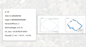
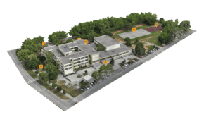
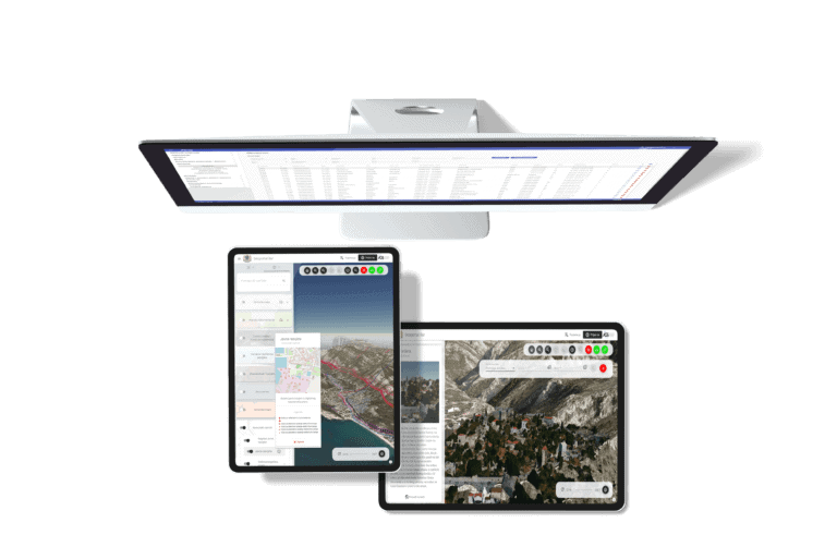
When you have the ability to visually visualize and understand resources and processes from start to finish, areas where you can improve efficiency will quickly emerge. Visualization, trend detection, simulation, virtual reality and digital twins will provide you with necessary information when you need it.
English
” />
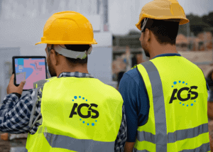
How can I use software solutions in the field?
All you need to do is use a smartphone or tablet and you have an internet connection. Our software solutions will provide everything else, the ability to collect data and manage the system.
English
How do we use software solutions if we don't have information about geospatial data?
AGS provides complete support to collect, process and publish data yourself. We also offer the option for us to collect data for you using various sensor techniques, UAV systems, LIDAR systems, satellite imagery, GNSS systems and to help you establish your data resource.
English
” />
Our clients and partners


