GIS software development

Use the full potential of resources

It's a solution tailored to your needs!

 The Geographic Information System (GIS) is a powerful tool that enables the collection, organization, analysis and visualization of spatial data. With GIS software, you can integrate geographic information with other data to gain deeper insights and make informed decisions.

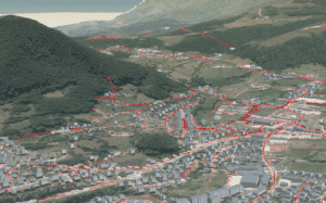
2D-3D Content Visualization

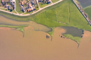
Our 2D visualization allows you to see and quickly analyze geospatial information on a flat surface. Easily navigate maps, explore the terrain, analyze data, and identify key points of interest. But that's not all! Our 3D visualization brings you a new perspective. Discover terrain from different angles, explore relief and slopes, visualize altitude changes and create realistic terrain models. This gives you the opportunity to better understand topography and spatial relationships, crucial for making informed decisions.

Prediction and analysis of data

Our platform also offers advanced smart prediction capabilities. Based on your existing data, we can help you identify trends and forecast future events. This gives you an edge in business, allowing you to plan ahead and manage resources efficiently.

Connect to real-time monitoring sensors

Connecting to sensors brings not only an abundance of data, but also the opportunity to impressively spatially display this information. Our platform allows you to visualize sensor data on interactive geographic maps and 3D models.

Development for mobile platforms

Our company is bringing a geospatial revolution to mobile platforms! With expertise in developing dedicated GIS solutions, we enable you to have all the advantages of a powerful Geographic Information System directly on your smartphone or tablet. With our dedicated GIS solution for mobile platforms, you can achieve maximum efficiency and precision in everyday work whether you are in the office or in the field.

Storing large amounts of spatial data in a safe place

In a world increasingly reliant on digital information, efficient and secure data storage is vital to a successful business. Our company is here to offer you a reliable solution to handle and store huge amounts of data in one secure place.

Your or our infrastructure

If your organization already has an existing GIS infrastructure and you want to keep control of your data, we can provide you with the ability to install on your infrastructure. If you want to reduce the burden of maintenance and infrastructure management, we can offer you the possibility of installing on our reliable infrastructure. Our servers are optimized for performance and security, providing you with a reliable environment for your GIS solutions.

Our company focuses on developing high-quality GIS software solutions that meet the needs of different industries and sectors. Whether you are engaged in urban planning, ecology, transport, agriculture or any other area that requires spatial analysis, our software can help you optimize your operations and achieve better results.

Schedule a presentation

Do you think our products can help your business?

Our clients and partners