Remote sensing
Don't give in to a single detail!
AI remote sensing is a combination of advanced artificial intelligence (AI) and remote sensing technology, enabling automated analysis of large amounts of geospatial data. This advanced approach provides deeper insights, faster processing and more accurate results in various areas, such as urban planning, agriculture, ecology, geology and many others.

Data preparation and processing
We offer comprehensive data preparation services that include field recording and the creation of precise spatial information as well as detailed data processing and processing. Whether you decide to take drone imaging with photogrammetry or LIDAR technology or to purchase high-quality azure satellite imagery, our expert team provides you with full support throughout the process.

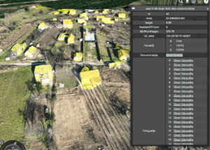
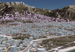
Creating forms for automated object recognition
The advantages of our AI remote sensing system are numerous. Using advanced algorithms, our software automatically identifies objects, shapes, patterns and field changes. This enables faster and more accurate detection, mapping and analysis of various phenomena. Also, our technology is continuously learning and improving, giving you ever better results over time.

Graphical representation of results with advanced tools
Our technologically sophisticated platform is designed to be fully compatible with your other applications, including AGS geoportal as well as other popular software and standardized formats to allow you to integrate and share spatial data smoothly.

Modern and fast data acquisition
We acquire data with modern geo technologies (UAV, GNSS, satellite systems, LIDAR, IoT, geosensors), processing with the help of modern tools and publishing in a web environment respecting ISO TC211 international standards and OGC recommendations. Our services and results are fully compatible with the requirements of these standards.

Monitoring changes in the field
Our remote sensing system enables faster detection and monitoring of changes in the field. Whether it's changes in vegetation, urban development, construction or other phenomena, our software automatically analyzes data and provides you with up-to-date information. Discover how this technology helps manage risks, monitor natural disasters and plan effectively.

Fast to a large amount of spatial data
With the help of advanced artificial intelligence (AI) technologies, our team of experts gives you fast and accurate access to a large amount of spatial data obtained from various sources such as satellite images, LIDAR images, thermal cameras and more. Collect a large amount of spatial data in the short term.
Our expert team has a deep understanding of the fields of photogrammetry, LIDAR technology, remote sensing and geoinformation engineering. It focuses on delivering outstanding results that allow you to make informed decisions, optimize resources and achieve the goals of your projects. Whether it's accurate terrain mapping, change analysis, 3D model creation or other AI remote sensing applications, our service is designed to support you every step of this inspiring process.

Our clients and partners


